The Nadeau Trail has been designated as a National Recreation Trail recently by Ridgecrest BLM. This is a favorite area of E. Clampus Waagus. Along this route are a number of very sensitive historical and natural resources that BLM Ridgecrest frequently reminds us that they are trying to protect (assumedly FROM the public at large? certainly from the frequent vandals that continue to roam the desert area). Now they come out with this...curious.
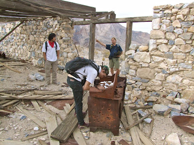
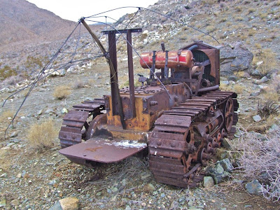
In any event, I have sprinkled a random sampling of photos of sensitive and easily destroyed sites along the "new" Nadeau Trail - a government advertised and promoted trail that will lead vandals straight to amazing sites like those shown in the photos. Most of these sites dated to the 1870's and 1880's, though a few are more recent. Click on any of the photos to enlarge them.
Don’t get me wrong - I don’t necessarily object to this, but do I detect a little bit of hypocrisy? Again, please convince me otherwise. Perhaps they do not find the sensitive sites along this route to be affected in any way by their designation of the Nadeau Trail and all its subsequent publicity. The Nadeau Road already exists and is on a map - why make it even easier to find by highlighting it in government websites? Those who roam and explore the desert for the beauty we are seeking will find these sites, as we have. Those that seek to pillage and destroy them have now been given directions here with this new Nadeau Trail road map.
Above: BLM Ridgecrest's map of The Nadeau Trail. Maybe it should be called a 4 wheel drive road? I'm used to the "trail" label being used to describe backpacking trails, such as the Pacific Crest Trail, the Appalachian Trail, etc. Note also that the map above identifies "The Nadeau Trail" as opposed to the "Nadeau Road". I believe that its historical name is the "Nadeau Road", and I know firsthand what a stickler the BLM is about naming things in a historically accurate way, though their success rate in this regard may need some help? Wonder why they decided to change its name to the Nadeau TRAIL from its historical name, the Nadeau ROAD?
The Nadeau Trail is situated along the eastern edge of the Argus Wilderness Range 5 miles east of Darwin, CA and 25 miles northeast of Ridgecrest, Calif. The Nadeau Trail provides motorized access through western Panamint Valley and ties in with cherry-stems and spurs leading to OHV, wilderness hiking, and backpacking opportunities. BLM Ridgecrest website goes on to describe the trail as follows (bold emphasis is mine):
“The Nadeau Trail has a fascinating history, from a place of geologic unrest and prehistoric petroglyphs to acting as the main corridor for Remi Nadeau’s freight wagons loaded with silver lead ingots headed down to Los Angeles in the 1800’s. History seekers, cultural explorers, and desert recreationists have an unlimited number of possible stops along the trail.”We encourage respectful visitation of these sites, and hope our government provides protection for these sites and prosecution of those who vandalize them. Sadly, there is little protection, except from private citizens, as far as I can tell. Through understaffing or lack of concern (we don't know which - they don't share their budget with us), our government provides little or no protection of these resources located on public lands - that we can detect, at least.
The national recreation trail program is jointly administered by the National Park Service and the U.S. Forest Service in conjunction with a number of other federal and nonprofit partners, such as American Trails, which hosts the national recreation trails website.
American Trails is concerned that California might opt out of the Recreational Trails Program.
“We have confirmed reports that Governor Jerry Brown’s administration is recommending that the governor opt out of the Recreational Trails Program, RTP,” the organization says on its website.
Just one more thing: a warning for you backpackers out there - the Naval Air Weapons Station China Lake cuts severely into your ability to explore the Argus Range, so take care to not get picked off by what we assume would be (in the post 9/11 world) military personnel protecting China Lake's eastern flank. Heck, you can't even bag Maturango Peak, as the entire thing has been claimed by Naval Air Weapons Station China Lake.
Some info on Maturango Peak from the website Summitpost.org: (again, emphasis is Mine):
"Maturango Peak is the highpoint of the Argus Mountains. This rugged Mojave Desert peak rises over 7,000' above the west side of the Panamint Valley. However, despite its impressive stature, Maturango Peak is somewhat of an unknown mountain. This is almost certainly due to the fact that the peak lies within the boundary of the China Lake Naval Weapons Station. Also, there are no maintained trails, roads, or campgrounds in the Argus Mountains. As a result of all these factors, it appears that few people ever venture out into this area. Other high peaks in the range include the 8,744' Parkinson Peak, and the 8,378' Parrot Point. Both of these peaks are situated just south of Maturango Peak, and are also located inside the military reservation. A road reaches the summit of Parrot Point, where a radio tower facility is located. The road continues on north and reaches the summit of Parkinson Peak as well. However, the road is off-limits to the public. There is no road to Maturango Peak."
In case you want to celebrate the opening of this Trail / Road, here are some details (note to self: h*ll no! it's too d*mn hot in PSR in August!):
Dedication of the Nadeau National Recreation Trail. Come and Celebrate ! August 22, 2013, Panamint Springs Resort, Death Valley National Park.
Agenda
10:00 am - Meet at Panamint Springs (Coffee, Air Conditioning)
10:30 am - Depart to Nadeau trail head (5 miles)
11:00 am - Welcome, VIP introductions, Ceremony and Ribbon Cutting
11:20 am - Return to Panamint Springs for lunch
12:00 pm - Lunch (pizza/salad/drink - $14.00) Slide Show, Comments
1:00 pm - Conclusion
Please RSVP to srazo@blm.gov by August 15, 2013.
8/24/2013 Update: A friend attended this event and reported back as follows: Big shots from BLM and National Park Service were there, along with the ordinary folks. No way I was going to attend in that heat! I guess it indicates that BLM and NPS both support this road, and the further looting and degradation of sites that it will bring. When will they learn?
8/24/2013 Update: A friend attended this event and reported back as follows: Big shots from BLM and National Park Service were there, along with the ordinary folks. No way I was going to attend in that heat! I guess it indicates that BLM and NPS both support this road, and the further looting and degradation of sites that it will bring. When will they learn?


No comments:
Post a Comment